 gCat
gCat
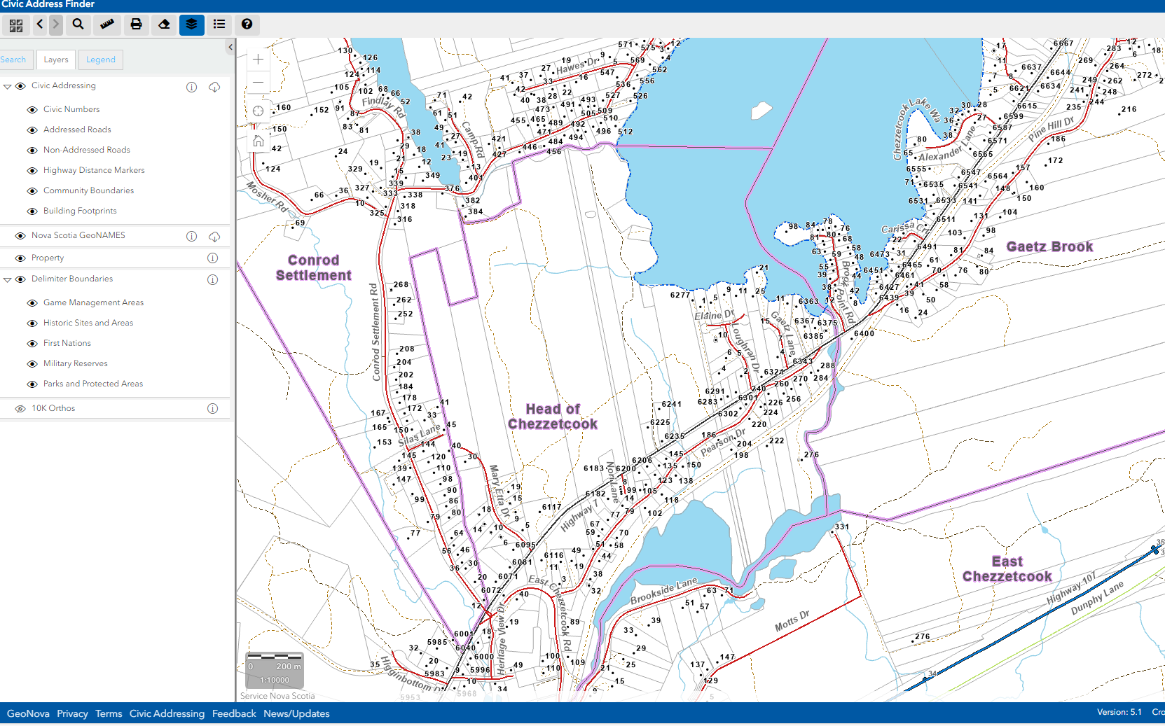
Nova Scotia Civic Address Finder
The Nova Scotia Civic Address Finder is an interactive web mapping application designed to help users locate and verify civic addresses across the province, using live information from the authoritative Nova Scotia Civic Address File (NSCAF) for pinpoint accuracy in emergency response, property searches, and daily navigation.
Launched as the upgraded successor to the original Civic Map Viewer, it offers a sleek, mobile-responsive interface with enhanced browser support and streamlined tools for exploring street names, civic numbers, road segments, and community boundaries.
Key Features
- Smart Search Bar: Type a civic number, street name, or community (e.g., "123 Main St, Halifax") to zoom instantly to the location, with auto-complete suggestions from the live NSCAF database.
- Layer Controls: Toggle civic points (red squares for centroids), addressable roads (blue polylines), range labels (e.g., "100–198 Even"), and basemaps like recent orthoimagery or hybrid views.
- Info Popups: Click any feature for details, full street name, left/right ranges, municipality, county, last edit date, and 3D coordinates in NAD83(CSRS).
- Print & Share: Generate custom PDF maps with legends, scales, and north arrows; copy links or export selections as KML for GIS import.
- Daily Updates: Reflects municipal and First Nations edits in real-time, ideal for validating new builds or spotting addressing gaps.
What’s Behind It
Built by Geographic Information Services - Government of Nova Scotia, it queries the central NSCAF Oracle database (updated daily by 50+ partners) to ensure every address is geo-referenced to within metres. Public version shows core info; secure logins unlock editing for authorized users like planners and E911 coordinators.
Example Use Cases:
- Homeowners confirming their civic number for signage or insurance
- Delivery drivers or realtors plotting routes with official addresses
- Emergency planners overlaying civic layers on hazard maps
- Developers integrating address validation into apps
- Municipal staff auditing coverage in rural areas
The application makes use of the following map services provided:
1) Nova Scotia Civic Address Finder Map Service (civic numbers, addressed roads, non-addressed roads, highway distance markers community boundaries, building footprints)
2) Nova Scotia Property Boundaries Map Service (parcel fabric with limited attribution)
3) Nova Scotia GeoNAMES Map Service (place and feature names)
4) Nova Scotia Topographic Database - Delimiters Map Service (Game Management areas, National Historic Sites, First Nations, Military Reserves, and Parks and Protected Areas
5) Nova Scotia 1:10,000 Orthophoto Map Service (colour rectified aerial photography)
6) Topographic Base Map Service (White) (background map)
7) Topographic Base Map Service (Colour) (background map)
The application is hosted in the Nova Scotia Geospatial Infrastructure (NSGI).
March 2023
Version 5.0 Update
The application has been rewritten using Version 4.x of the ArcGIS API for JavaScript. While the core functionality of the application remains the same as its predecessor, major differences include the following:
- Previous/next extent functionality improved
- Application is supported on both desktop and mobile devices.
Simple
Identification info
- Date (Creation)
- 2006-05-04T00:00:00
- Date (Publication)
- 2023-03-10T00:00:00
- Date (Last Update)
- 2023-03-10T00:00:00
- Edition
-
Version 5.1
- Edition date
- 2023-03-23T00:00:00
- Cited responsible party
-
Role Organisation Electronic mail address Custodian Geographic Information Services - Government of Nova Scotia
- Presentation form
- Digital map
- Purpose
-
This public map application allows users to find and view civic addresses and places in Nova Scotia using a variety of map services. Civic addressing is important for the delivery of many services including 911 Emergency Services, mail and home delivery, utility connections, municipal permitting and Nova Scotia Government programs and services.
- Credit
-
The Civic Address Finder is produced by Nova Scotia Civic Addressing Program, Geographic Information Services, Government of Nova Scotia. Contributing partners include provincial, municipal and indigenous governments who work collaboratively to manage Nova Scotia's authoritative civic addressing database.
Map services utilized by this application are provided by Geographic Information Services.
- Status
- Completed
- Point of contact
-
Role Organisation Electronic mail address Point of contact Geographic Information Services - Government of Nova Scotia
- Topic category
-
- Planning cadastre
- Imagery base maps earth cover
- Society
- Transportation
Extent
- Description
-
Nova Scotia
))
- Maintenance and update frequency
- As needed
- Date
- 2019-09-25
- Date type
- Revision
- Hierarchy level
- Application
- Theme
-
-
civic address
-
addressing
-
civic addressing
-
house numbers
-
addressing system
-
find address
-
addresses
-
- Place
-
-
Nova Scotia
-
- Platform
-
-
NSGI
-
Nova Scotia Geospatial Infrastructure
-
- Product
-
-
Published_External
-
Public
-
Open
-
Application
-
Map App
-
Resource constraints
- Use limitation
-
Disclaimer:
Government of Nova Scotia makes no representations, expressed or implied, as to the accuracy, completeness and timeliness of the information, maps and other data, including PID numbers or property boundaries, which are displayed in this application.
The data is provided on the understanding that it is not guaranteed to be correct or complete or current, and conclusions drawn or decisions made, based on an interpretation of the data, are the responsibility of the user.
By continuing to use this application, you agree to the terms of this disclaimer.
- Hierarchy level
- Application
Resource constraints
- Use limitation
-
This application is classified as Public according to the Nova Scotia Information Security Classification System.
- Hierarchy level
- Application
- Classification
- Unclassified
Resource constraints
- Use limitation
-
This public application is made available under the Open Government Licence - Nova Scotia. You are encouraged to use the information that is available under this licence with only a few conditions. https://novascotia.ca/opendata/licence.asp
- Hierarchy level
- Application
- Access constraints
- Licence Unrestricted
- Use constraints
- Licence Unrestricted
Associated resource
- Association Type
- Cross reference
- Metadata Reference
- Language
- English
- Country
- CA
- Character encoding
- UTF8
Distribution Information
- Distributor contact
-
Role Organisation Electronic mail address Publisher Geographic Information Services - Government of Nova Scotia
- OnLine resource
-
Nova Scotia Civic Address Finder
Use this application to find addresses and places in Nova Scotia, Canada.
- OnLine resource
-
Nova Scotia Civic Addressing Website
Browse this website to find out more about Civic Addressing in Nova Scotia, Canada.
Resource lineage
- Statement
-
September 2019 Updates
New & Improved Civic Address Finder released
The NS Civic Address Finder Viewer is no longer dependent on a single web browser, it works with all web browsers! The map is now more responsive and interactive. We welcome your feedback, please let us know what you think of the new Civic Address Finder via the Feedback link in the page footer.
See below for a list of other things that have changed.
New layers have been made available to the public:
Highway Distance Markers
Nova Scotia GeoNames
Delimiter Boundaries
Game Management Areas
National Historic Sites
Indian Reserves
Military Reserves
Parks and Protected Areas
Orthophotos (full provincial coverage!)
Some datasets are now available for download:
Civic Addressing
Nova Scotia GeoNames
New tools have been added:
Change Basemap
Enhanced search capabilities allow searching by:
Street Name
Community Name
GeoName
Towns
Villages
Communities
Lakes, etc.
Location
XY
Decimal Degrees
Degrees Minutes Seconds
Enhanced Measure Tool
Distance
Area
Location
There is also now a Legend and a Layers List with the ability to toggle layers off and on.
About Civic Addressing in Nova Scotia
Civic addressing is much more than a collection of community names, street signs, and numbers on homes and businesses. It is a complex system that involves the public, municipalities, First Nations, government departments, emergency response, and service providers; and is used for everything from pizza delivery, emergency response, bus routing, to elections.
In 1997, the Province of Nova Scotia identified a need for a province wide electronic, geo‐referenced location based address database, and as a result the Nova Scotia Civic Address File (NSCAF) was created.
The NSCAF project would help provide a standard, geo‐referenced electronic database of civic addresses province wide and a supporting maintenance strategy to maintain the data going forward. It would assigned proper addressing to every home and business in Nova Scotia, and was fundamentally managed as a spatial database, using geo-referenced points (civic locations), lines (road segments), and polygons (communities) to define the location of the addressing elements and their georeferenced context.
Over time most residents came to learn that every home and business in Nova Scotia is assigned a civic address consisting of a street name, civic number, community and county names but most were not aware is often how to find out what their proper civic address is.
To help with this problem, the Province created the Nova Scotia Civic Map Finder, an online mapping application used to view civic map information, with a free public viewer version and another version containing more information for certain parties that need more detailed information and the ability to update the information of the Nova Scotia Civic Address dataset.
- Hierarchy level
- Application
Metadata constraints
- Use limitation
-
This metadata is classified as 'Public' according to the Nova Scotia Security Classification system.
- Classification
- Unclassified
- User note
-
This metadata is 'Unclassified' according to the ISO Information Security Classification system.
Metadata constraints
- Use limitation
-
You are encouraged to use the Information that is available under this licence with only a few conditions. https://novascotia.ca/opendata/licence.asp
- Access constraints
- Use constraints
- Maintenance and update frequency
- As needed
Metadata
- Metadata identifier
- urn:uuid/e6fe2db4-8d55-4fdd-b719-48dca63f0988
- Language
- English
- Country
- CA
- Character encoding
- UTF8
- Contact
-
Role Organisation Electronic mail address Author Geographic Information Services - Government of Nova Scotia
Type of resource
- Resource type
- Application
- Name
-
Nova Scotia Civic Address Finder
- Metadata linkage
-
https://gcat.gatewaygeo.ca/geonetwork/srv/api/records/e6fe2db4-8d55-4fdd-b719-48dca63f0988
- Date info (Creation)
- 2025-11-04T14:14:12.390831Z
- Date info (Creation)
- 2025-11-04T12:56:39.290911Z
- Date info (Revision)
- 2025-11-04T14:25:05.292326Z
- Date info (Creation)
- 2025-09-23T12:35:04.371847Z
- Date info (Publication)
- 2024-06-25T21:17:26-03:00
Metadata standard
- Title
-
ISO 19115-3 (2018)
)))